


When the ground moves in South Asia, it rarely does so quietly. A deep rupture beneath the Himalaya can roll through mountain valleys, rattle the plains of northern India, sway towers in Dhaka, and send anxious families into the streets from Kathmandu to Kolkata. In those long seconds, the region feels less like a collection of countries and more like one connected geological body — a vast, stressed crust still adjusting to one of Earth’s greatest collisions.
Hero image caption: Dramatic 3D cross-section of the Indian–Eurasian collision zone, showing the Indian Plate diving beneath the Himalaya, folded crust, active faults, and seismic energy radiating toward the plains of South Asia.
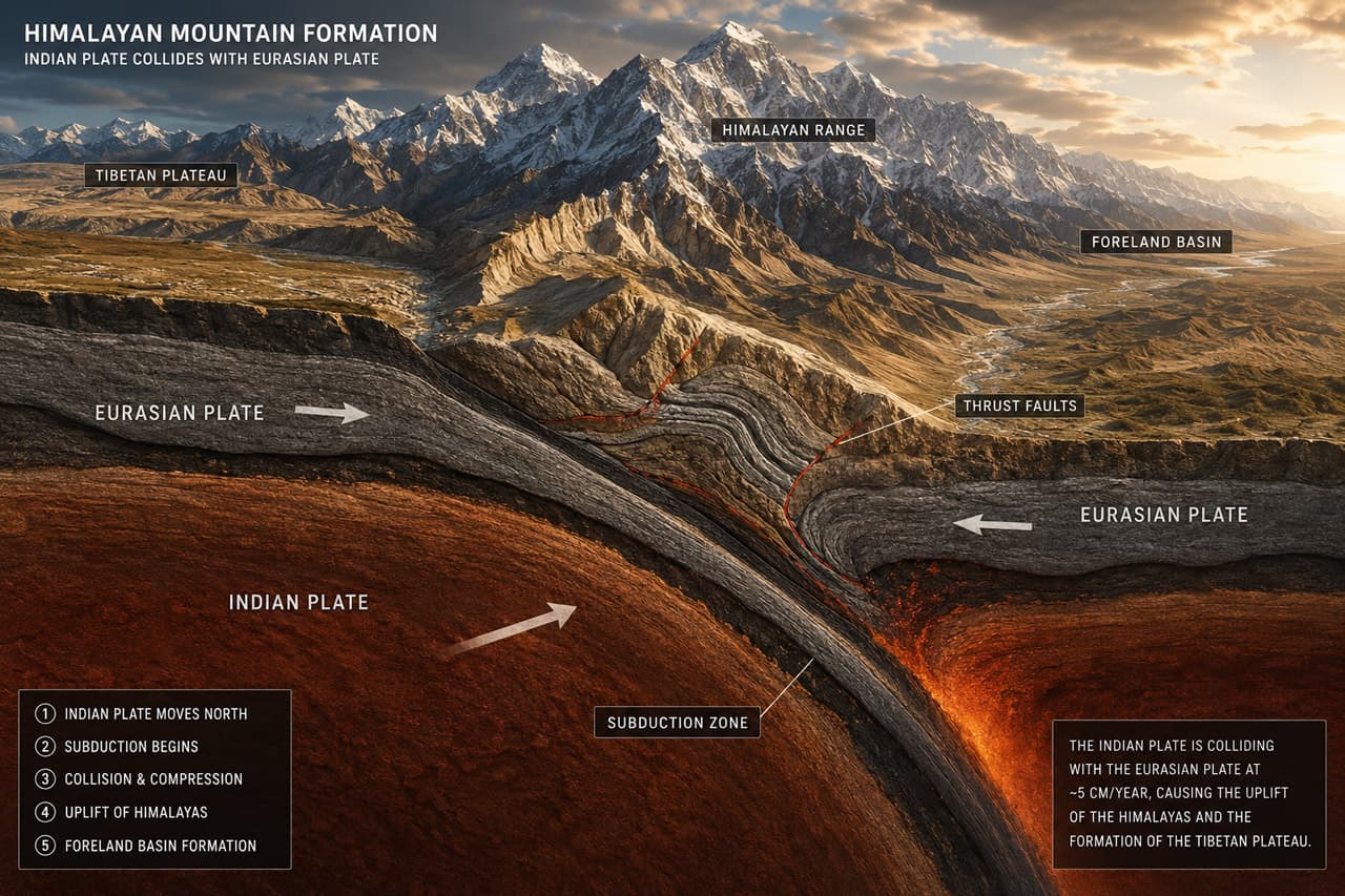
Two Giants Collide
The story begins with motion. Around 50 million years ago, the Indian Plate — once an island continent racing northward across the vanished Tethys Ocean — slammed into the southern edge of Eurasia. Unlike oceanic crust, which can sink neatly into the mantle, two buoyant continental plates resist easy subduction. The result was not a clean disappearance, but a crumpling.
That crumpling built the Himalaya.
Today, the collision continues. The Indian Plate still pushes northward into Eurasia at roughly 4–5 cm per year across the Himalayan region, according to broad geodetic and seismotectonic estimates. That may sound slow, but in geological terms it is relentless: fingernail-speed motion capable of raising mountains, bending crust, and storing enough elastic strain to rupture in devastating earthquakes. The Himalaya and nearby ranges are therefore not relics of an ancient event; they are active machinery. (USGS)
| Plate name | Plate type | Approx. speed | Boundary type | |
|---|---|---|---|---|
| ————————————— | ————————————— | ———————————————- | ————————————————– | |
| Indian Plate | Continental / oceanic composite | ~4–5 cm/yr north-northeast relative to Eurasia | Continental collision / underthrusting | |
| Eurasian Plate | Continental | Slow relative motion; deformed by India’s push | Convergent collision zone | |
| Burma / Sunda-related microplate system | Mostly continental-margin / arc-related | Variable, oblique motion | Strike-slip and subduction-influenced boundary | |
| Arabian Plate | Continental / oceanic composite | ~2–3 cm/yr northeast | Collision and transform interactions west of India |
The central drama is simple: India moves; Eurasia resists; the crust shortens, folds, fractures, and occasionally breaks.
Reading the Fault Lines
A tectonic map of South Asia looks like a page filled with scars. Along the Himalayan front, major thrust systems — including the Main Frontal Thrust, Main Boundary Thrust, and the deeper Main Himalayan Thrust — mark zones where the Indian crust is being driven beneath the mountain belt. Farther east, the collision bends around the eastern Himalayan syntaxis, where the structure turns sharply toward northeast India, Myanmar, and the Indo-Burman ranges.
Faults are not just lines on a map. They are surfaces of weakness, sometimes locked for centuries, sometimes creeping, sometimes waiting. When stress overcomes friction, a fault slips. That slip sends seismic waves outward, and the landscape records the violence: landslides, liquefaction, offset river terraces, cracked roads, and raised scarps.
“You can walk along an exposed fault scarp and feel the earthquake frozen into the hillside — one side lifted, the other dropped, like the land itself has kept a memory of the rupture.”
One useful way to think about stress is through a simple pressure-like relationship:
σ = F/AHere, σ is stress, F is force, and A is the area over which that force acts. In plain language: the same force becomes more intense when concentrated over a smaller area. In tectonics, enormous plate-driving forces are distributed through rocks, faults, and plate boundaries. Where stress concentrates — at bends, locked patches, fault intersections, or rigid blocks — the crust becomes more likely to fail.
Coulomb stress analysis builds on this idea by asking whether stress changes on one fault make nearby faults more or less likely to slip. After a major earthquake, the surrounding crust is not reset to zero; stress is redistributed, sometimes loading neighboring segments.
Major earthquakes in the Indian–Eurasian collision zone include:
- 1897 — Shillong Plateau / Assam, magnitude ~8.1: A major rupture associated with the Shillong Plateau region.
- 1934 — Bihar–Nepal, magnitude ~8.0–8.2: One of the most destructive Himalayan earthquakes, damaging large areas of Nepal and northern India. (<a href="https://en.wikipedia.org/wiki/1934Nepal%E2%80%93Indiaearthquake?utm_source=chatgpt.com”>Wikipedia)
- 1950 — Assam–Tibet, magnitude 8.6: The largest instrumentally recorded Himalayan earthquake, linked to the eastern syntaxis region. (<a href="https://earthquake.usgs.gov/earthquakes/eventpage/official1950081514093430/region-info?utmsource=chatgpt.com”>USGS Earthquake Hazards Program)
- 2015 — Gorkha, Nepal, magnitude 7.8–7.9: A devastating thrust earthquake on the Main Himalayan Thrust system, felt across Nepal, India, Bangladesh, and Tibet. (<a href="https://en.wikipedia.org/wiki/April2015Nepalearthquake?utmsource=chatgpt.com”>Wikipedia)
Bangladesh in the Seismic Frame
Bangladesh is often imagined as a river delta — flat, fertile, and shaped by the Ganges, Brahmaputra, and Meghna. But beneath that soft alluvial surface lies a more complicated tectonic reality. Bangladesh sits near the meeting zone of three major geological influences: the Himalayan collision to the north, the Shillong Plateau and Dauki fault system to the northeast, and the Indo-Burman fold belt to the east.
This position matters.
The country is not located on the high Himalayan front itself, yet it is close enough to receive strong shaking from large Himalayan or northeastern Indian earthquakes. At the same time, eastern Bangladesh lies near active fold-and-thrust structures related to the Indo-Burman ranges, where oblique convergence and crustal shortening continue. The Sylhet region, Chattogram Hill Tracts, and northeastern margins are especially important in seismic hazard discussions because they sit near active structural boundaries rather than in the quieter interior of a plate.
The delta also amplifies risk. Thick layers of young, water-saturated sediment can strengthen shaking at certain frequencies, much like jelly wobbling more than rock. In low-lying urban areas, liquefaction — where saturated ground temporarily behaves like a fluid — can damage foundations, roads, embankments, and buried utilities. For a megacity like Dhaka, even a distant earthquake can become dangerous if shaking is amplified by local soil conditions and dense construction.
What the Maps Tell Us
Modern seismic maps combine many kinds of evidence: GPS measurements, historical earthquakes, active fault traces, satellite imagery, geological fieldwork, and computer models of stress transfer. Together, they reveal a sobering pattern. South Asia’s seismic belt is not a single line but a broad, interconnected zone of deformation.
The Himalaya stores strain along locked thrust faults. Northeast India contains complex fault networks around the Shillong Plateau, Assam valley, and eastern syntaxis. Myanmar and the Indo-Burman ranges add another tectonic system, where strike-slip and compressional motion interact. Bangladesh lies between these worlds — downstream of Himalayan rivers, adjacent to northeastern faults, and west of the Indo-Burman arc.
Maps also show uncertainty. Some faults are well mapped; others are buried under sediment. Some earthquake histories are written in instruments; older ones survive only in damaged temples, colonial reports, river changes, and disturbed sand layers. This uncertainty does not reduce the hazard. It reminds us that the landscape may know more than our catalogues.
Bangladesh’s vulnerability is therefore unique: it combines proximity to several active tectonic zones, soft deltaic ground, high population density, rapidly growing cities, and critical infrastructure built across floodplains. The country is not merely near the Indian–Eurasian collision — it is framed by its consequences. To map South Asia’s seismic belt is to see Bangladesh not as a passive delta at the edge of the mountains, but as a frontline society living beside one of Earth’s most powerful geological engines.


Responses (0 )